Ways you can Help
850-933-6286
Report Artifacts That Are Found
Like Us On Facebook
DONATE
Aucilla Research Institute
  • Home
    • What we Do
    • Meet our People
    • Calendar
    • Gallery
  • Resources
    • Virtual Museum
    • Education
    • Member Publications
    • Newsletter
    • Aucilla River News
    • Year in Review
  • Participation
    • Associate Scholars
    • Volunteer
    • Financial Support
  • Research
    • Projects >
      • Way We Were Series
      • Wakulla Mysterious Waters
    • Current Events >
      • The Wacissa Slave Canal
    • Spanish Missions
    • Borderland Conferences >
      • First Floridian Series
    • Research Library >
      • Royal Society Paper
      • Mapping Processes
      • Sea Level Changes
  • Contact
    • Directory
  • SiteMap

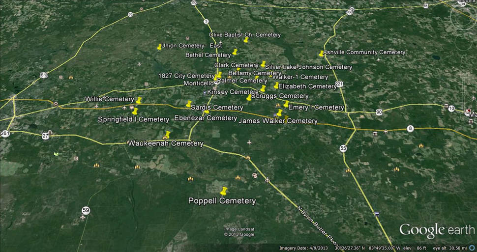
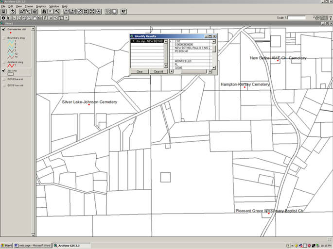
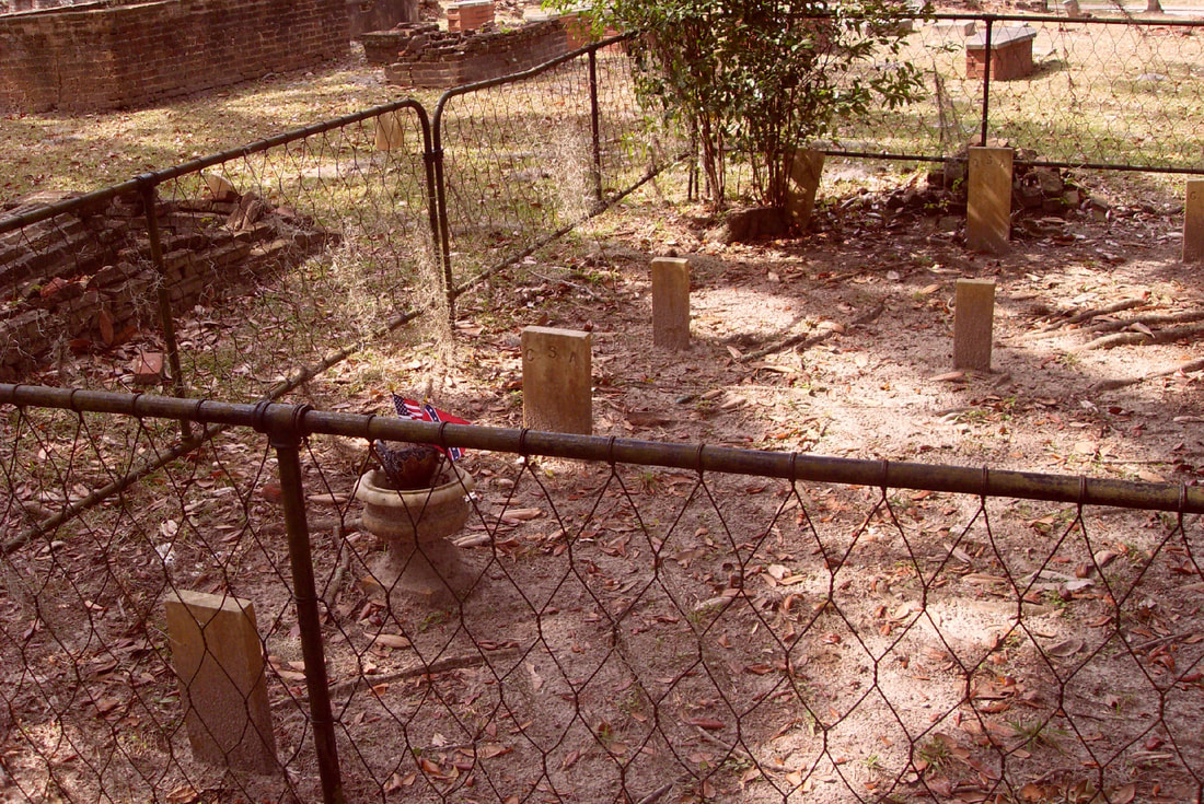
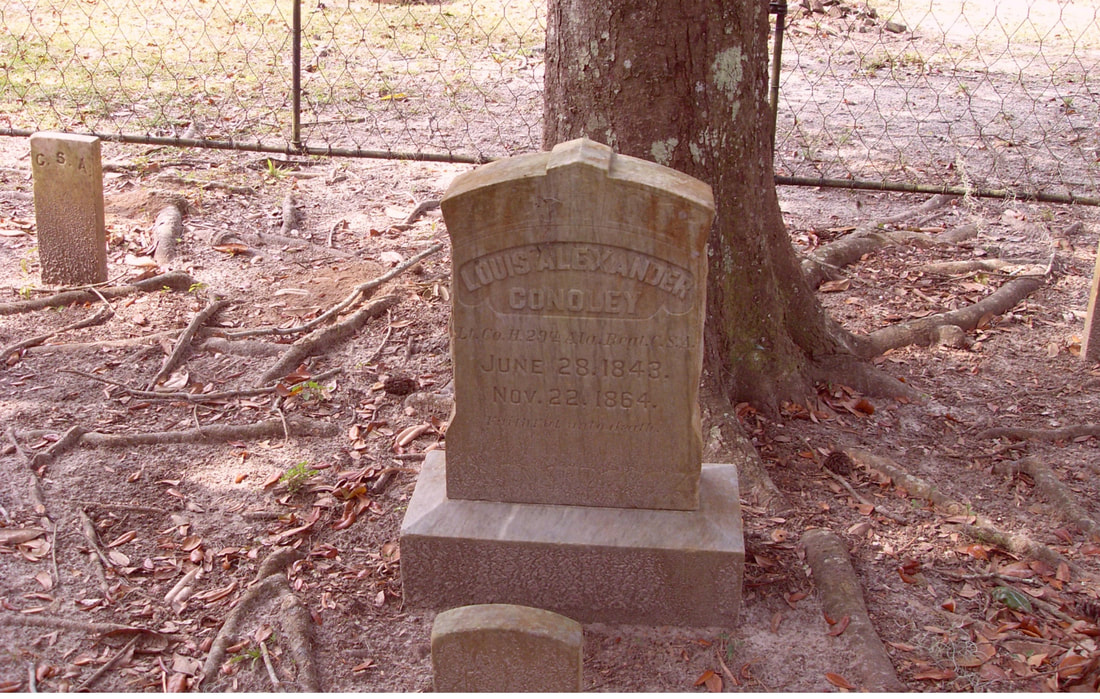
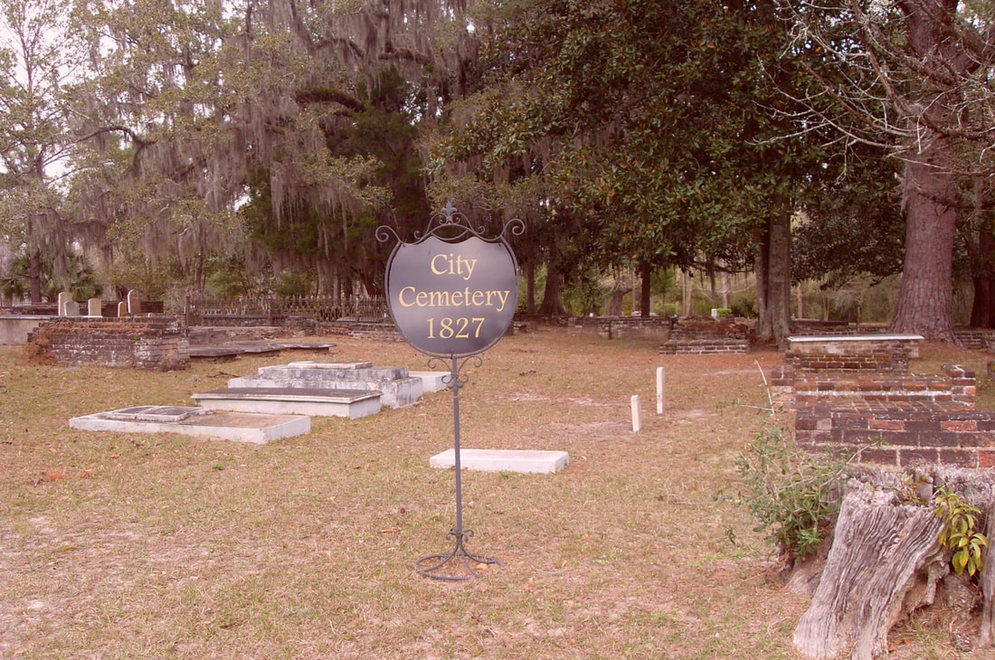
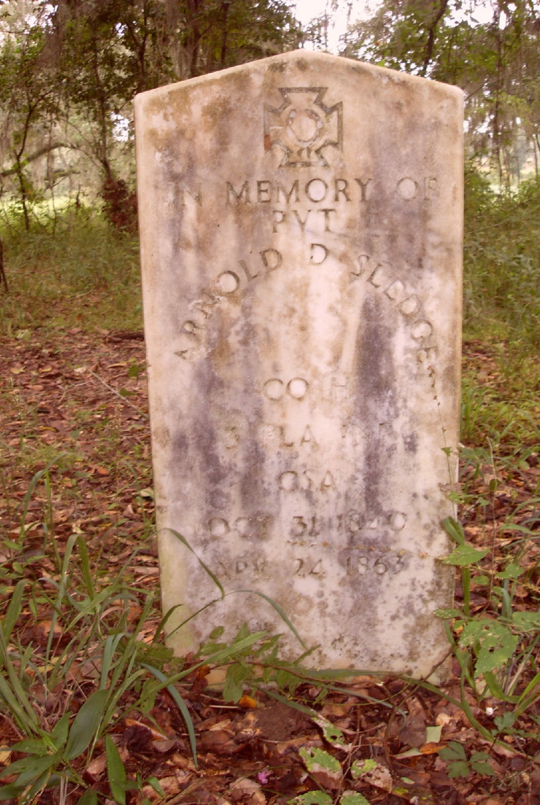
Jefferson County Cemeteries Mapping Project

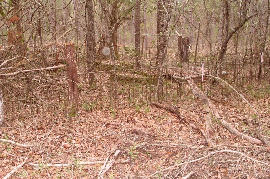
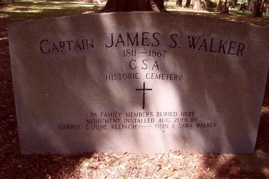
Jefferson County has an abundance of historical treasures.  Among these are the numerous small cemeteries which are scattered about our county that are among the most striking evidence of Jefferson County’s rich history.  Some have as few as one or two grave stones and include the many family cemeteries created by early settlers in the county as well as those established by various churches.  Many of these have grave stones dating well before statehood for Florida.  Other examples include evidence of Native-American and Spanish settlements. Unfortunately, with multiple changes in ownership, agriculture practices, and land development, some of these treasures have been lost.  Others have been long ignored and are overgrown and thus almost impossible to locate.  With those losses, important parts of our history have been lost.

Jefferson County Cemetery Mapping Project
To stem that loss, a comprehensive inventory of the cemeteries in the county has begun.  As a starting point for the project, the Keystone Genealogical Library provided a written list of a number of cemeteries, along with a census of those cemeteries as of the 1950s. That list had been compiled by the late Mrs. Theo Delp.

Click on list by Names or Cemetery to find grave and inscription information, CSA for Civil War Veterans and Cemetery Locations
  • LIST BY NAMES
  • LIST BY CEMETERY
  • CSA BY NAME
  • CEMETERY MAP LOCATIONS
<
>
Scroll on blank document to see names in alphabetical order for each cemetery.
The Inscriptions list is long and wide for this page, but is available as a download. Click on the file and open for a list of names, dates and the cemetery location.
inscriptions_sorted.xlsx
File Size: 368 kb
File Type: xlsx
Download File

Cemeteries with grave information are underlined and highlight.  Click CSA for list of Civil War Veterans at each site.
1827 City Cemetery     CSA
Alexander Cemetery
Alford Cemetery
Alfred William Raysor Cemetery
Anderson Cemetery
Ashville Community Cemetery    CSA
Avalon Cemetery Welaunee
Bailey/Mayes Family Cemetery     
Bailey-1 Cemetery
Bailey-2 Cemetery
Beasey-Carroll Cemetery
Bellamy Cemetery      CSA
Beth Page Cemetery   Excel
Bethel Cemetery
Bishop Cemetery     CSA
Blackburn-Cobb Cemetery
Boland Cemetery
Bradley Cemetery see Elizabeth Bradley Cem.
Braswell Cemetery
Broomsage Cemetery
Browns Cemeterysee Rocky Branch Cem.
Bunker Hill Cemetery
Byrd Family Cemetery
Campbell Cemetery
Casa Bianca Cemetery
Christ Church Memorial Garden
Clark Cemetery      CSA
Clayton Family Cemetery
Cody Cemetery
Cooksey-Nalley Cemetery
Corley Cemetery
Durrin Place Cemetery
Ebenezer Cemetery       CSA
El Destino Cemetery
Elizabeth Cemetery     CSA    UPDATE
Elizabeth-Bradley Cementery
Ellis/Humpres Family Cemetery
Ellis-McKinnie  Cemetery
Emery Cemetery      CSA
Finlayson-Boyd Cemetery
Forest Lawn Memorial (Fincher) Cemetery
Gilmore Cemetery
Glendower Plantation Cemetery
Grantham Cemetery
Greater Elizabeth Cemetery
Groover Cemetery
Hampton-Kersey Cemetery
Harp Cemetery
Hatchett Place Cemetery
Herndon Cemetery
Hickory Hill Cemetery
Hopefull Cemetery
Howard/Richardson Family Cemetery
Humprey Cemetery
James Cemetery
James Walker Cemetery
Jeff Brown/Faglie Cemetery
Jefferson Landing Cemetery
Jerusalem Cemetery I
Jerusalem Cemetery I I
Johnson Cemetery (Brock Road)
Jones Cemetery
Kinsey Cemetery     CSA
Leach Cemetery
Lloyd Cemetery
Lott Cemetery
Macedonia Freewill Baptist Ch. Cemetery
Mahan Park Cemetery
Mary Thomas Cemetery
McPhate/Fabian Cemetery
Miller-Bond Cemetery
Morris I Cemetery
Morris II Cemetery
Mt Mariah Primitive Baptist Ch. Cem
Mt Marilla Cemetery
Mt Moriah I Cemetery
Mt Moriah I I Cemetery
Mt Olive AME Church Cemetery
Mt Olive Cemetery
Mt Zion AME Cemetery
Mt Zion Cemetery
Mt Zion II Cemetery
New Bethel AME Ch. Cemetery
New Bethel Cemetery
Oakfield Cemetery
Old Aucilla Church Cemetery     CSA
Old Greenville AME Church Cemetery
Old Slave Cemetery
Olin Walker Cemetery
Olive Baptist Ch. Cemetery    CSA
Palmer Cemetery      CSA
Pinckney Hill Plantation Cemetery
Pleasant Grove Missionary Baptist Ch.
Poppell Cemetery      CSA
Rainey Cemetery
Reid Cemetery
Rocky Branch Cemetery
Roseland City Cemetery     CSA    UPDATE
Salem AME Cemetery
Sandwich Cemetery
Sardis Cemetery     CSA
Sardis Methodist Ch. Cemetery
School Tract Grave Site
Scruggs Cemetery     CSA
Shehee Cemetery
Silver Lake-Johnson Cemetery    CSA
Simpson Cemetery
Sneeds Cemetery
Snyder/Story Cemetery
Springfield I Cemetery     CSA
Springfield I I Cemetery
Springfield Methodist Ch. Cemetery
St Phillips AME Church Cemetery
St. Pauls AME Church Cemetery
Stephen Walker Cemetery
Stokes/Sanders Cemetery
Stokley Cemetery
Suber Cemetery
Sweetfield Cemetery
Texas Hill Cemetery
Thomas Hashell Walker Cemetery
Tudor Cemetery
Turnbull Cemetery
Union Branch AME Methodist Church Cemetery
Union Cemetery     CSA
Unknown 1 Cemetery
Unknown 2 Cemetery
Uze Bradley Cemetery
Walker Family Cemetery
Walker-1 Cemetery     CSA
Walker-2 Cemetery
Waukeenah Cemetery     CSA
Welaunee Cemetery
Wigginsville Church Cemetery
Williams Cemetery
Willie Cemetery     CSA
​

Scroll on the blank document to reveal names.
Scroll on the blank document to reveal names and locations.

​With the assistance of volunteers, that beginning census was laboriously typed into a digital file. Each of those cemeteries, as well as many others pointed out by long-time county residents was visited and re- inventoried. In addition, a geographical position (latitude and longitude) for each cemetery was measured using a Global Positioning System (GPS) receiver.  As the information was gathered, it was added to the digital file
 
Having the data in a digital format as well as having geographic coordinates associated with each cemetery has allowed easy searches through the data as well as the use of modern geographic technology to identify, map, and document the historic cemeteries in the county.  As originally developed, it could be viewed in a geographic information system (GIS) overlaid on aerial photography or the County’s land parcel map or, it could be viewed through Google Earth.
Cemeteries with Civil War Veterans
CSA where listed under cemetery listing
Picture
Cemeteries with Civil War Veterans
​By adding a geographic location and modern mapping technology to historical research, the project has the potential to accomplish several functions.  Most importantly, it will preserve the precise location of an important part of our history by identifying those locations on a map to allow the physical location of  cemeteries if they are lost in the furure.  Further, those locations will be associated with specific land parcels which will allow protection of the sites if the land is being developed or otherwise used in a way that could inadvertently destroy the cemetery. In addition, it provides a useful tool for genealogy research. 
 
The addition of the cemetery to the County’s property appraisal geographic system will allow preservation of the data that has been collected in the public records, make it more readily available to researchers, as well as allowing its consideration in the permitting process for land development. Also, by making it available for public review, will allow for comment to correct omissions or errors.
Picture
Cemetery Locations as viewed on a county map
​It should be stressed that the data base is intended as a starting point. It is far from being complete or free of errors. As an example, while only 86 cemeteries have been inventoried, there are over 60 more that have been reported but have yet to be precisely located and inventoried. But once they have been set up in an organized manner, we will attempt to restart an effort to locate and inventory more of them.
 

Samples of Typical Cemetery Views
Picture
Picture

CEMETERIES
Important Parts of our History

Home

Resources

Participation

Research

Contact


Aucilla River Tides
Conferences
Floridan Aquifer
SiteMap
Newsletter

The ARI website was funded in part by a grant from
​The Perkins Charitable Foundation.
Picture

    Subscribe to the ARI Newsletter

Subscribe to Newsletter
Virtual Museum Entrance
Member Publications
Current Events
Member Resources  
Copyright © 2018
​Designed by NOW Productions Co
.